Satellite Coal Mine Methane Observation Map
An interactive map showing the potential of methane emission detection, via satellites, at worldwide coal mining sites throughout the year
Updated March 2025
Anchor point: Data tool
Anchor point: About
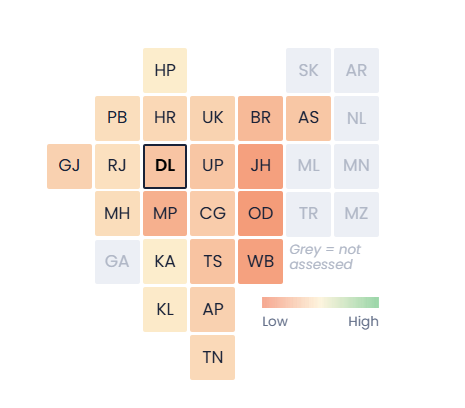
About
For its first 20 years in the atmosphere, methane’s warming impact is 80 times that of carbon dioxide. Despite coal mines releasing methane, emissions are accurately tracked at very few sites. Spaceborne methane monitoring techniques, using satellites, are becoming a key tool for tracking global methane emissions – providing insights, which can be used by governments, industry, and civil society organisations.
In Ember’s report “The Geography Factor”, analysts assessed the impact of environmental factors on the effectiveness of spaceborne methane monitoring techniques. This data tool, originally featured in the report, displays the varying potential for satellite methane detection across operational coal mines worldwide – factoring in the effects of annual cloud cover, sunlight availability, solar zenith angles, elevation, and wind patterns, among other variables.
Anchor point: Methodology
Methodology
Read more about our methodology here.
Anchor point: Contact

Related Content

Data tools
Wind and Solar Capacity Data Explorer
The latest monthly data on wind and solar capacity, including total installed capacity, month-on-month and year-to-date additions across 25 countries and economies, covering around 93% of global solar capacity and 92% of global wind capacity.
Last Updated: November 14, 2025
Data tools
Indian States’ Electricity Transition (SET) Data Tool
India’s overall electricity transition depends on state-level action. Explore how states are progressing across transition parameters including solar and wind capacity addition, energy storage, as well as enabling policies for renewable energy integration and electric vehicle (EVs) adoption
Last Updated: November 14, 2025
Data tools
Coal Mine Methane Data Tracker
The latest coal mine methane emissions, projections, production data, and policy context by country, available freely and openly to accelerate global coal mine methane reduction efforts.
Last Updated: November 14, 2025

Data tools
China Cleantech Exports Data Explorer
A tool to uncover insights from the latest clean technology export data from China, including solar PV, batteries and electric vehicles. Explore by electrotech type, country or region.
Last Updated: November 14, 2025